CNES projects library
C
I
M
P
S
U
Bi
Goce
For more than 4 years, the European GOCE satellite (Gravity field and steady-state Ocean Circulation Explorer) circled Earth at an altitude of around 260 km. To compensate for the effects of atmospheric drag in this very low orbit, the satellite was equipped with ion thrusters, without which it would have fallen back to Earth in a matter of months.
Why such a low orbit? Because the gravity field’s attraction is stronger the closer we get to the centre of the Earth, making it easier to measure the tiny spatial variations caused for example by ocean trenches, mountains or movements inside the planet’s mantle.
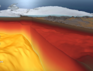
GOCE’s measurements have enabled scientists to map Earth’s geoid with unprecedented accuracy at a spatial resolution of 100 km. The geoid is the surface of an ideal global ocean in the absence of tides and currents, shaped only by gravity. It serves as a reference surface for numerous other missions and scientific studies. For example, GOCE data are widely used to determine mean sea surface height, thermohaline circulation and ice thickness, and therefore to better understand climate change and its impacts. They are also of great value in geophysics.
GOCE was the first Earth Explorer mission selected by ESA, in 1999. CNES’s space geodesy team is part of the European consortium tasked with generating science and operational products from GOCE data.
GOCE complements the GRACE mission (Gravity Recovery And Climate Experiment), which since 2002 has been observing temporal variations in Earth’s gravity field due notably to tides, ocean currents and changes in polar ice cover, at a lower resolution of around 200 km.
Mission's news feed
-

Gravity mission still unearthing hidden secrets
Despite ESA’s GOCE mission ending over seven years ago, scientists continue to use this remarkable satellite’s gravity data to delve deep and unearth secrets about our planet....
March 11, 2021
-
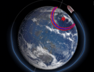
GOCE reveals what’s going on deep below Antarctica
Gravitationnal and sismological data give a glimpse of the deep structure of the continent under its kilometers of ice.
December 13, 2019
-
GOCE a seismometer in orbit around the Earth
Most people think that seismometers are ground-based instruments, but today earthquakes can also be detected by satellites.
March 11, 2013